

But Midtown’s contemporary identity takes on new significance when one examines the history of the district. Over its lifetime, the neighborhood has been a bottleneck of crime and murder, a suburban retreat for the city’s white elite, an unsavory zone of urban blight, an artists’ colony, the epicenter of Atlanta’s gay community, and an award-winning example of urban renaissance.1 Peeling back these layers of Midtown’s identity reveals struggles over the space of the neighborhood in both symbolic and material terms, in part captured by the various place-names assigned to the district since the Civil War. Bound to constellations of historical conditions, factors, and human values, Midtown’s series of place-names, which often overlapped or contradicted one another at various points in the neighborhood’s lifetime, reveal that the neighborhood’s development was not entirely straightforward.The meaning and power of place-names stem from how they fit into the larger public debates, anxieties, and values of a given period. Place-names function as a cultural shorthand – a means to know about the neighborhood and its residents without ever having to experience it firsthand. The act of assigning a place-name to a given location renders the unfamiliar familiar and helps to stabilize an unwieldy landscape into a more manageable space with a clearly defined identity. However, place-naming is rarely a consensual process, as scholars have increasingly come to recognize.2 Examining place-names allows us to see how space and social behaviors, architecture, politics, gender, and culture intersect to manifest neighborhood identity via such commonly used cultural shorthand. Moreover, tracking the histories and conflicts over place-names reveals the plurality of stakeholders at work in any given locality.
These might include not only agents of mainstream political, commercial, or consumer cultures, but also those of counter-hegemonic subcultures such as hippies in the 1960s and 1970s or the LGBT community.In the case of Midtown, various place-names were circulated in the mainstream and later underground press, and were employed by neighborhood residents, real estate interests, and City Hall, each with clear implications for the built environment. When stakeholders deployed place-names in struggles to claim public spaces as their own and justify their occupation, use, and control of the neighborhood’s built environment, they also legitimized development policies, land-use changes, or investment decisions that shaped the contours of Midtown’s political, economic, and cultural development. Tracing Midtown’s history of conflicting place-names also illuminates who exactly was involved in those historical struggles, and their priorities and values, as well as the extent of their ability to exert control over the neighborhood’s built environment. This human dimension of Midtown’s development points to the multitude of cultural landscapes that corresponded to, crosscut, or contradicted those “official ones” created by politicians, bureaucrats, planners, developers, and investors. Since Midtown’s place-names influenced definitions of who was worthy or unworthy of access to public space and what constituted acceptable uses of that space, they also reveal the ways those definitions were resisted, engaged, or reappropriated in struggles for a new urban order on the north side of Atlanta.
The story of neighborhood struggles over space in Midtown begins with the fall of Atlanta during the Civil War. As Don H. Doyle has pointed out, “when the smoke cleared,” the city “had to adjust to what contemporaries referred to as ‘the new order of things.’”3 For traumatized Atlantans, that new order included reconciling the influx of freedmen, ex-Rebels, morphine addicts, destitute women, and farming families who experienced the tremendous upheaval of the Civil War.4 Ultimately, housing shortages and extant racial tensions forced members of these vulnerable groups to settle in the low-lying bottomlands and valleys that surrounded the city.
But with law and order difficult to maintain in the city, the roads between Atlanta and its outlying suburbs were extremely dangerous. Where the Margaret Mitchell House and the Federal Reserve stand today in the heart of Midtown was one such suburb. At the time, the territory north of Third Street was beyond the city limits, and the section of Peachtree Street that forms the backbone of Midtown today was little more than a crooked wagon road winding its way through the dense wilderness of the Peachtree Ridge. The little hamlet, known as “Tight Squeeze” took its name from the section of road that negotiated the surrounding hills and valleys, making a westward bend around a deep gulch located near the present-day Peachtree and Tenth Street intersection before returning to its course around where Eleventh Street is now.5 “Tight Squeeze” made frequent appearances in the Atlanta Daily Intelligencer with published reports of quarrels, family feuds, murder, and highway robbery. For nearly three decades, Tight Squeeze was consistently represented as an uncivilized wilderness where strange and uncouth people milled about.
To some, the name of the locality referred to the character of the road, which was so narrow that it was a “tight squeeze” for two vehicles to pass each other; to others, the name stemmed from the fact that maneuvering around the gulch and its murderous inhabitants meant it took “a mighty tight squeeze” to get through with one’s life.”6 Others connected the moniker to prostitution, although to one Philadelphia Times correspondent “none of the girls looked pretty enough to warrant the name of the place.”7 At any rate, the village’s unsavory reputation emerged in late 1865, when the Atlanta Daily Intelligencer described the complaints of country people who had their wagons stopped and pillaged at gunpoint on Peachtree Road, and demanded that the occupying military take steps to restore order in the vicinity.8 Since Peachtree served as a main route of travel between Atlanta and the northern territory beyond Buckhead, traffic funneled through the narrow bottleneck in the road outside the Atlanta city limits, and in the desperation and destitution of the post-Civil War years, it became a common practice for highwaymen to waylay persons loaded with cash and goods as they slowed down to ease around the ravine.9In 1867 criminal activity in Tight Squeeze reached a fever pitch that provoked a public outcry to clean up the area. Following the murder and violent assault of two sons from prominent pioneer families the Daily Intelligencer published a report lamenting “that lawless characters infest every thoroughfare leading into this city, and industriously ply their hellish vocation.”10 In response to these attempts at murder and robbery “upon respectable persons returning from the city of Atlanta,” the Fulton County Grand Jury recommended “raising a force of secret detectives” to patrol and safeguard the roads leading into the city.11
After the publication of the paper’s recommendation, virtually no mention of Tight Squeeze was made throughout the remainder of the 1860s and throughout the early 1870s. This quiet on the city’s fringes corresponded with the stabilization of building operations, the reestablishment of business and finance institutions, and the opening of new lines of transportation into undeveloped sections of the city. And as Atlanta continued to grow and expand in the early 1870s, residential suburbs slowly crept farther north along Peachtree Street, prompting landholders in areas beyond the city’s northern border to organize promotional schemes advertising parcels for sale in the newly designated town of “Blooming Hill.”12
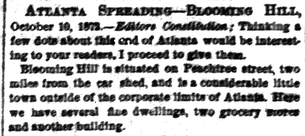
Named for supposed acres of blooming trees and pastures to the west down present-day Tenth Street, “Blooming Hill” suggested a bucolic retreat for city residents. Such imagery played well in the context of Atlanta’s rapid recovery from the war, with enhanced economic prosperity and transportation advancements like streetcars that spurred the growth of fashionable suburban retreats for the city’s wealthier residents. Landholders of property in Blooming Hill seemed poised to profit when city limits were extended north on Peachtree almost to the present-day intersection with Fourth Street in 1872.13 That same year the Methodist Protestant Church laid the foundations for the Blooming Hill Mission, situated on the east side of Peachtree just north of what is now Eighth Street.14But for a number of reasons, Blooming Hill failed to develop into the “considerable little town” advertised in the press. The area was still outside the corporate limits of the city and inaccessible by public transportation; Peachtree Road was still unpaved, narrow, and crooked; and the national financial Panic of 1873 brought building operations to a standstill.15 At the same time, speculative landholders in the area ended their public relations campaign in the press for Blooming Hill. As the area’s reputation as a village of rustic people predisposed to drinking and raising hell had persisted, Tight Squeeze reemerged as the moniker of choice for the suburban settlement by the late 1870s.
By then, Tight Squeeze consisted of a wagon yard, a blacksmith shop, and small wooden stores on the western side of Peachtree, while up and down the gulch on the eastern side of Peachtree were the shacks of village inhabitants known as “Tight Squeezers.”16 Tight Squeezers were poor, their homes shabby, and their children unkempt. Feared, abhorred, and openly mocked in the press, the village and its inhabitants were treated with a derisive editorial voice that described local women as prostitutes or “Amazons” and the men as effeminate or incapable of settling a dispute without resorting to gunfire.17 Tight Squeeze remained notorious for prostitution, murder, and the drinking habits of its locals until the 1880s, when County Commissioners used convict labor to fill in the ravine and straighten out Peachtree Road in preparation for the 1887 Piedmont Exposition.18
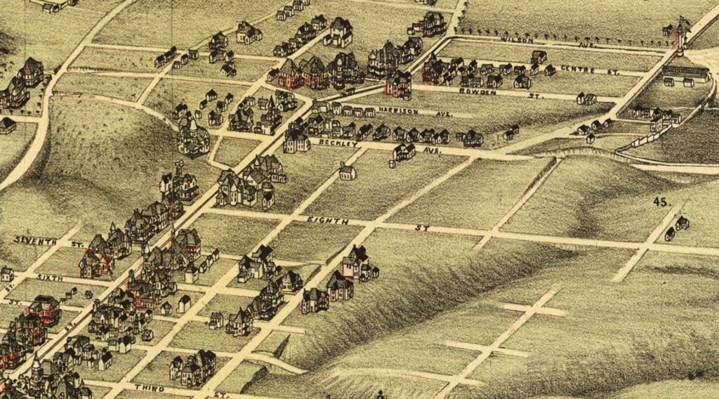
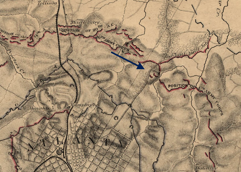
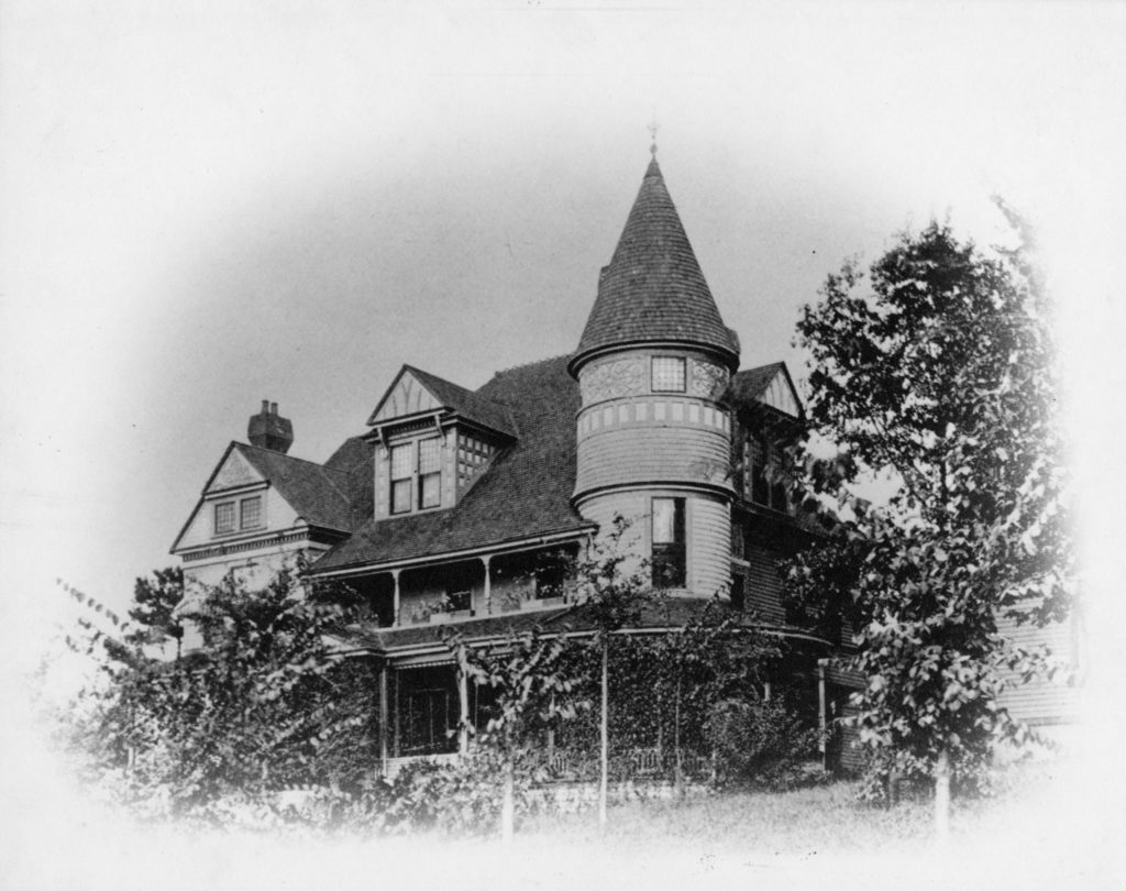
After the widening and grading of Peachtree during the 1880s and the extension of the city limits northward to about Sixth Street, the area developed into a desirable residential enclave for the city’s white elite that historian Franklin Garrett once called the “Fifth Avenue of Atlanta.”19 Residential development along Peachtree Street between North Avenue and Eighth Street eroded Peachtree Street’s country character, as prominent merchants, bankers, lawyers, and architects built lavish homes near the old Tight Squeeze village.20 Building activity in North Atlanta further accelerated after the Cotton States and International Exposition of 1895, when streetcar tracks on Piedmont Avenue were extended to Piedmont Park’s main entrance at present-day Fourteenth Street with loops at both Tenth and Fourteenth Streets that connected to the Peachtree line, as visualized in the map above.21By the 1890s, Tight Squeeze had come to be known as “North Atlanta,” an area marked by wealth and privilege and described as “the most aristocratic and fashionable part of the city.”22 As one editorial gushed,23The architect of North Atlanta’s new white elite residential geography was Richard Peters, who platted his considerable holdings into large lots and sold them at high prices, attracting the city’s elites to the north side of town.24 Indeed, as William Bailey Williford has pointed out, “the residents of Peachtree between 1885 and 1910 reigned with unquestioned supremacy.”25
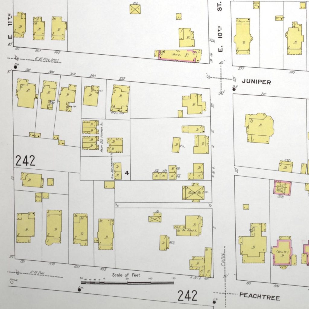
North Atlanta developed prior to the imposition of residential segregation ordinances and the rise of planned neighborhoods and subdivisions.26 As such, in spite of its development, the area as a whole was nonetheless noticeably mixed by class, race, and function. While North Atlanta was defined by the beauty of the sumptuous mansions and manicured lawns of Peachtree Street, traces of Tight Squeeze remained into the 1910s north of Eighth Street. The block bounded by Peachtree on the west, Eleventh Street on the north, Juniper on the east, and Tenth on the south was home to laborers, carpenters, draymen, butlers, and gardeners, who lived in modest dwellings situated at the very heart of the block, in the bottom of what had once been the Tight Squeeze ravine.27 Although the structures varied in style – the four closer to the eastern edge of the block were built in shotgun style – they were all single-story, wood frame constructions that lacked plumbing and were only accessible via a ten-foot alley that ran between 8 East Tenth Street and 10 East Tenth Street. Thus while Peachtree was straightened out and transformed into the “Fifth Avenue” of Atlanta by the partial filling-in of the ravine, the undesirable low-lying gulch area remained an affordable housing option for working-class people. Clusters of structures in backyards like this one often shared sanitary facilities. This block – like many similar working-class residences in Atlanta during the period – lacked water and a sewage system, an issue that plagued the area until advent of city planning in the 1910s.28
Though the residential geography and haphazard built environment of North Atlanta persisted into the first decade of the twentieth century, by the early 1910s the presence of new planned suburbs to the north saw the conversion of the neighborhood from residential to commercial. As LeeAnn Lands has pointed out, while Peachtree Street was identified locally with “the city’s commercial-civic elites and eventually enjoyed easy access to downtown by carriage or streetcar, the area lacked the deliberate planning that marked the exclusive park-neighborhood communities” like Ansley Park just to the north.29 Such neighborhoods were kept exclusive by “adopting deed covenants: legal restrictions that limited or dictated how an individual property could be used.”30 Ansley Park, with its restrictive covenants and strict zoning requirements that effectively mandated residential segregation, became a welcome haven for Atlanta’s white elite who wanted to escape the chaotic development pattern that arose south of Fourteenth Street.
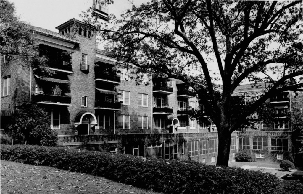
As the central business district around Five Points grew to accommodate the increasing number of banking, insurance, and convention businesses, and homeowners moved farther out, hybrid commercial-residential areas developed in areas like Little Five Points in Inman Park and along Tenth Street near Piedmont Park. 31 And as Ansley Park came into its own as an elite residential neighborhood, the intersection at Peachtree and Tenth Streets became a hybrid commercial center with a tenant-based residential sector. Since the neighborhood was considered too close-in for homeowners who sought open space, elegant apartment buildings were built near streetcar lines and the once stately homes of the elite were chopped up into apartments and boarding houses or were razed entirely to make room for even more multi-unit dwellings.32

The business area around Tenth Street expanded considerably with locals referring to the district along Peachtree Street from Eight to Fourteenth Streets as the “Peachtree-Tenth Street Area.”Atlanta historian Franklin Garrett described this shopping district as “a lady, a good-looking, viable retail center sort of like Lenox Square today,” an appropriately gendered description given the fact that in the 1940s, men irreverently referred to the district as “hen heaven,” because at almost any hour of the day there were probably more women and children per square foot in the area than almost anywhere else in Atlanta.33 Department stores, men’s specialty shops, beauty shops, stores specializing in juvenile clothing and furniture, laundries, a Citizen & Southern National bank branch, a post office, automobile service stations, restaurants, hardware shops, poultry shops, and delicatessens all attracted women from miles around not just because of the sheer variety of businesses, but also because of the area’s reputation for the quality of goods dispensed. More than a business district, Tenth and Peachtree was a social center, with its early success linked to its “unique ‘village’-type atmosphere.”34 But by the 1940s, recognition of the importance of automotive accessibility and consumer decision-making began, with one observer noting “greater accessibility and less traffic congestion are major considerations in selecting a location in which to spend money.”35 The charming village of Tenth Street, however, like other in-town shopping centers including Little Five Points and West End, was not easily accessible by car, a characteristic that would lead to its demographic change by the post–World War II era.
Although many commentators point to the late 1940s and early 1950s as the beginning of Peachtree and Tenth’s economic downturn, this period also marks the beginning of the neighborhood’s bohemian and countercultural upswing. As William Bailey Williford pointed out in the 1960s, “Peachtree Street, that stately dowager of one-time elegance, had deteriorated in recent years to a series of rather dowdy boarding house districts.”36 While wealthy Atlantans abandoned the area and many of the long-established merchants followed their consumers to the shopping centers in more suburban locations, the void created by these moves was filled with less affluent families and individuals – young and old. Such changes introduced a reduction in the area’s resident purchasing power and a change in the type of retail goods and services needed to support this new population. The result was a decrease in the number of grocery stores and other enterprises oriented to the home-owning family-unit consumer (groceries, hardware, furnishings, appliances; laundries, cleaners; variety stores; drug stores), and an increase in the number of enterprises more oriented to the tenant-type individual consumer (restaurants, cafes, coffee shops, bars; auto service and repair; beauty and barber shops; jewelry, antiques, and art; galleries; book stores; stationery stores; finance companies).37 Most notably, the neighborhood became a favored destination for students at the nearby Atlanta College of Art and other young people attracted by jobs, cheap rent, and an assortment of cultural offerings unavailable elsewhere in the city.38 By the late 1950s, as the neighborhood gained a bohemian reputation, it was said that,
Around Tenth Street you are likely to do your shopping alongside a bearded young man and girls in ‘toreador’ trousers, part of the uniform of the neighboring art colony, and the grocery cart can include phonograph records of the newest jazz, picked up from the reverberating music shops demonstrating bebop.39
“Around Tenth Street you are likely to do your shopping alongside a bearded young man and girls in ‘toreador’ trousers, part of the uniform of the neighboring art colony, and the grocery cart can include phonograph records of the newest jazz, picked up from the reverberating music shops demonstrating bebop.By the 1960s, the area had come to be known as the “Hip Strip” as young southerners of the flower child and psychedelic set were drawn to it by its “artistic aura, its reasonable rents, convenience of transportation, and shopping facilities.”40
The hippies’ reappropriation of derelict structures in the neighborhood that had been left to decay by absentee landlords offered greater community sustainability and redefined the neighborhood in countercultural terms. For example, the low-rise commercial structures situated on the corners of the Peachtree and Tenth Street intersection were rented out and fixed up by groups of people who set up galleries and shops that employed locals in workshops that in turn provided merchandise for the crafts shops which provided the revenue to support the whole cooperative operation. Such establishments were not only evidence of the hip community’s buying power, suggested the Great Speckled Bird in 1970, but also models for a “new social order” in the neighborhood.41 Although the artistic and bohemian sets were attracted to the area for the cheap rents, amenities, and culture, other interests saw the demographic changes in the area as problematic.
Comprised of Atlanta businessmen and property owners, the Uptown Association Inc., formed in 1962, saw the area as a “safe haven for the criminal element” plagued by “decay, deterioration, and blight.”42 Business interests brought the area under intense scrutiny throughout the 1960s. Prior to this period, the six-block strip of Peachtree Street had been bypassed by investor-developers because of the comparatively high land costs and the parcelization of the land into small, separately owned tracts which were in turn subdivided into several leaseholds, thus rendering significant assemblages difficult and in many cases impossible.43According to a 1969 area analysis conducted by V. Stuart Ward Jr., the director of planning for the Cushman Corporation, investor-developer efforts to seize control of the area’s orderly growth were hampered by two changes to the area – “one political and one sociological.” The first change involved the city’s attempts to solve a complex traffic problem plaguing the area: following the recommendations of the Traffic Engineering Department, the Board of Aldermen eliminated curbside parking along Peachtree Street and restricted cross-town traffic flow on Tenth and Fourteenth Streets to one-way movements. The overall effect ended up complicating access to and from the area and “materially reduced the ‘trade area’ which the Tenth Street retail district could serve.”44
The sociological issue described in Ward’s area analysis illuminates a competition for control of the neighborhood’s future and identity with the hippie and countercultural groups whose social and cultural practices conflicted with the goals of the investor-developers of the Uptown Association, Inc. According to Ward’s analysis, Tenth Street was “plagued by an influx of the so-called ‘Hippies,’ a sociological subculture” he hoped was “transitory in both its choice of a locale or base of operations and in its capacity to sustain itself.”45 These competing views illustrate the heightening of struggles over the neighborhood as new groups of people moved into the area and attached meanings to the space, redefining the “community” through their cultural practices.
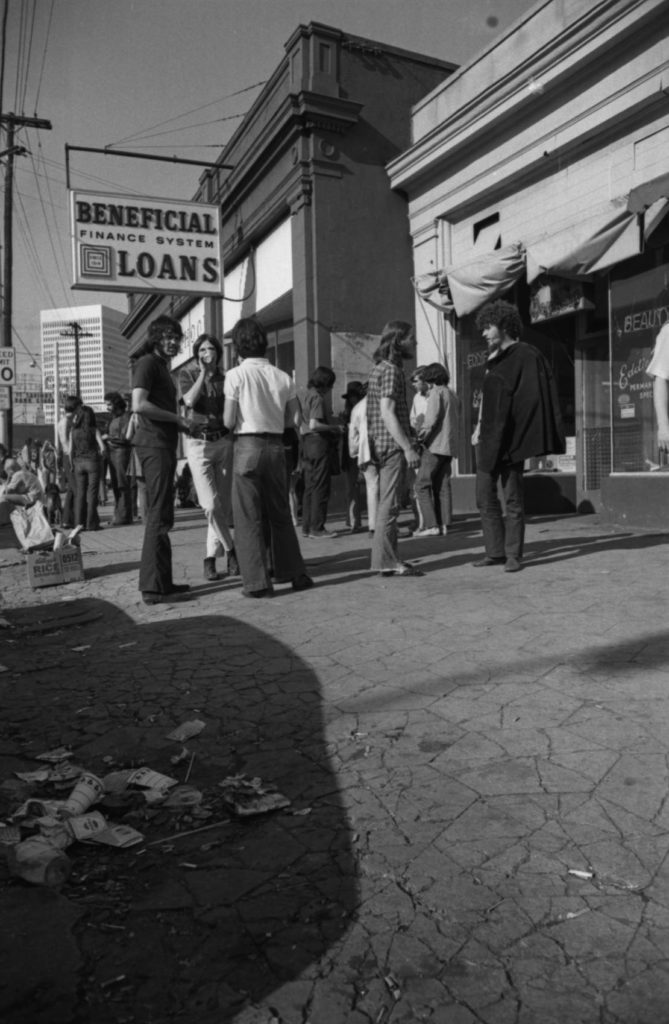
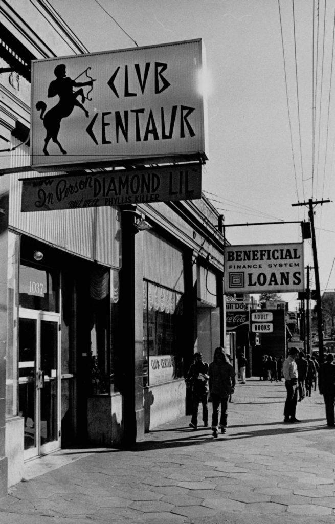
Although throughout the 1960s the artist colony in the Uptown area would continue to be celebrated as the “Hip Strip,” by the 1970s the balance of power there shifted in favor of the Uptown Association, as their claims to the area were lent further legitimacy by sensationalized national coverage that portrayed the area via images of chaos, decay, and deterioration. In a column for the May 31, 1970 issue of the Atlanta Journal, editorialist Eugene Moore even revived the “Tight Squeeze” moniker for the area when representatives of social service agencies located in the neighborhood asked for his advice on a proper name for the area. 46 A month later, a press release published in the Great Speckled Bird rejected Moore’s moniker in favor of, simply enough, “The Community.”47 Eugene Moore’s “Tight Squeeze” revival article was only one of many depicting the area as a cultural and economic black hole. According to the Atlanta Constitution, long-term “straight” business owners even “lived in dread of hippies,” fearing retribution if they attempted to protect their livelihoods.48 Then, on June 4, 1970, mayor Sam Massell delivered a televised address for local affiliate networks in which he maintained that all citizens, even hippies “are protected by law” and deserving of the same constitutionally protected freedoms enjoyed by all Atlantans. However, in that address Massell also suggested that the runaway children, plastic hippies, biker gang members, and professional heroin pushers, were “attracted to [the] area by the atmosphere [hippies] created in the community.”49
While the hippies and counterculture re-appropriated the storefronts and houses, jammed the sidewalks, or attracted gawking out-of-towners who clogged the streets with traffic, the visibility of the “artist colony” they originally created combined with the city’s civil rights legacy to create a larger public image of Atlanta as a cosmopolitan alternative to the small towns across the South. As a result of the cosmopolitan reputation that Atlanta and the “Strip” had earned in the 1960s, the area also became an epicenter for Atlanta’s gay male community. Despite continued police intimidation and crackdowns stemming from the increased visibility of homosexual communities in Atlanta,50 by the 1970s the proliferation of gay-oriented bars, bookstores, and other businesses illustrated the economic power of the local gay community, a power that was especially relevant in the context of urban revitalization.
Indeed, according to Atlanta Constitution staff writer Ron Taylor, Atlanta’s gay community “has had a significant, though often secret, impact on the city’s business and cultural affairs,” and additionally, “gays were in the forefront of the back-to-the-city movement, being among the first to buy and renovate the burned-out storefronts and houses in areas of the city that had been abandoned for the suburbs.”51 Just as the community helped stimulate Midtown’s residential redevelopment, the proliferation of new businesses in the area that were gay-owned, gay-operated, or catered to a gay clientele helped revive the neighborhood’s commercial district.52 Furthermore, the establishment of groups like the Atlanta Business and Professional Guild, “a kind of gay chamber of commerce,” which formed when many banks refused to lend money for residential projects in the early 1970s, facilitated the restoration of historic homes in Ansley Park, Virginia Highland, Morningside, Inman Park, Midtown, “and other now fashionable Atlanta Communities.”53 In effect, the Guild helped to consolidate the economic and political power of the gay community in the formation of geographically distinct areas of influence like Midtown.54
At the same time perceptions of the gay community were changing, “The Community” envisioned by the hippies and other countercultural groups receded, tied as it was to images of decay, deterioration, and blight. But as large-scale developers turned their attention to the neighborhood as a prime urban investment location, their gaze was met by the Uptowne Neighborhood Association (UNA). Comprised of area residential property owners, the UNA emerged in 1968–69 to combat deterioration and protect the neighborhood’s residential character from commercial encroachment. Chaired by Atlanta architect Henri Jova, the UNA’s mission was to encourage homeowners to stay in the area and to attract other families and young professionals. The area remained attractive, he believed, because it “still had a nice supply of single-family and duplex houses at a low price, and a lot of trees.”55 Through municipal building code enforcement, as well as through the influence of Central Atlanta Progress,, the UNA promoted the area to young families and young professionals with a “combined purchasing power in the millions of dollars,” facilitating investment projects involving the beautification of Peachtree Street through tree planting, storefront restoration, and the eviction of unsavory adult entertainment businesses.56
By the late-1970s, the area had entered a “renaissance” and assumed a new name. The social and economic restructuring of the neighborhood ushered in by the gay community’s reinvestment and the organized efforts of the UNA persuaded large-scale developers to invest in the neighborhood locals were now calling “Midtown.” As Henri Jova explained, the decision was made after Phipps Plaza launched an advertising campaign in which it referred to itself as “uptown”: “If they were uptown, it was difficult for us to call ourselves ‘Uptowne,’ so we became Midtown.”57 The newly named Midtown Neighbors’ Association continued to represent residential interests, and in 1978 business and civic leaders formed the Midtown Alliance to promote the development of the Peachtree Street corridor, today known as the Midtown Improvement Disctrict.58 Zoning changes to parking requirements and building heights encouraged investment from big businesses like IBM, AT&T, and Bellsouth to build high-rise office complexes in the area, while also reducing the presence of gay bars and nightclubs, making the neighborhood more attractive to heterosexuals and their families.59 Though residential and commercial neighborhood stakeholders frequently contested one another’s vision of the neighborhood’s identity, the place-naming of the area as “Midtown” was nonetheless underpinned by social, political, and economic processes that emphasized property value preservation and enhancement.60
While Midtown’s name hasn’t changed since the late-1970s, its current revitalization suggests that the neighborhood’s character has. Although Midtown maintained its status as the epicenter of gay life and business through the 1990s, the shuttering of gay businesses and bars since the beginning of the twenty-first century illustrates the continued struggle among stakeholders for control of the neighborhood’s political, economic, and social restructuring. But as a history of Midtown’s place-names have shown, changes in neighborhood character are nothing new; rather, they are a part of the neighborhood’s ongoing urban development, as such changes are tied to the ebb and flow of new groups of people with new ideas, priorities, and values. By reassessing the various place-names that the area we know today as “Midtown” has held over the past century and a half – from “Tight Squeeze” and “North Atlanta” to “Tenth Street Area,” “Hip Strip,” and “Uptown(e)” – we gain new insights into the long history of social struggles that have altered the ways the area has been used and defined, shaping the Midtown we know today. And just as Midtown’s place-names illuminate larger patterns in Atlanta’s urban growth and development on the north side of the city, interrogating the place-names assigned to other areas of in-town Atlanta might reveal conflicts behind the development of these corners of the city.
Cover Image Attribution: “10th Street.” Photograph. Atlanta, GA, October 1960. From Kenan Research Center, Atlanta History Center: Central Atlanta Progress, Inc. Photographs, http://album.atlantahistorycenter.com/cdm/ref/collection/caprogress/id/12.
